
價格:免費
更新日期:2019-06-13
檔案大小:127.5 MB
目前版本:7.13.2
版本需求:需要 iOS 11.0 或以上版本。與 iPhone、iPad 及 iPod touch 相容。
支援語言:俄文, 匈牙利文, 土耳其文, 巴克摩文挪威文, 德語, 捷克文, 斯洛伐克文, 日語, 法文, 波蘭文, 烏克蘭文, 簡體中文, 繁體中文, 羅馬尼亞文, 義大利文, 芬蘭文, 英語, 荷蘭文, 葡萄牙文, 西班牙文, 韓語, 馬來文, 保加利亞文
The No.1 downloaded fishfinder app with great features for planning fishing trips, this free app can be used with or without a deeper sonar
With the most downloads of any fishfinder app, Deeper is the best app for smart anglers. It works with or without a Deeper sonar and boasts great features for planning fishing trips and maximising your catch rate. Know when to fish, know where to fish, then measure depth, find your targets, reel them in, log your catches and share on social media. All in one app.
Features anyone can use:
Plan your next angling trip with the solunar calendar and weather forecasts.
Log every catch. Use the notes function to keep a detailed record of your best catches.
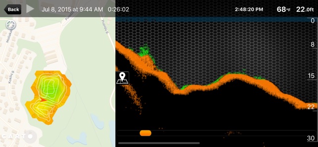
Map your trip. Download maps (which you can then use offline), then mark your favourite spots.
Share your catches with fellow anglers using the app’s in-built camera mode. Just snap that trophy catch and share on social media.
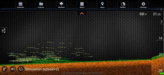
Discover Deeper. See how a fishfinder can revolutionise your fishing by running the sonar simulations.
Then take your smart angling to the next level by using the Deeper app together with a Deeper smart sonar (explore our product range at www.deepersonar.com). Combined with one of these fishfinders, the Deeper app turns your smartphone into a high-grade sonar display.
Get data to enhance your angling - depth, temperature, bottom structure, vegetation, fish location and more, all displayed live on your smartphone screen.
Take control of your sonar readings with fully adjustable sensitivity, adjustable fish and depth alarms, a range of display options and a choice of narrow or wide beam scanner.
Choose different modes for different types of angling. Use it as a fishfinder and sonar from the shore, as an ice flasher in ice fishing mode, or map out the waters you fish in boat mode.
Create bathymetric lake maps direct from the shore in onshore fishing mode (only with the PRO+ model) or with a Deeper sonar mounted to your boat or kayak (works with all models).
View and analyse your lake maps on your home computer using Lakebook – the Deeper Data Manager. Login at maps.deepersonar.com to see your maps and download raw mapping data.
Map and mark every ice fishing hole and store data from your Deeper sonar for every location in Ice Fishing mode.
Store all your angling data collected from your Deeper smart sonar with unlimited data storage in the app.
App Features that work without a Deeper Smart Sonar
* Free to download
* Solunar fishing activity calendar - view month / week / day / hour.
* Weather forecast - temp; wind; humidity; pressure; sunset / sunrise; moonset / moonrise.
* Fishing log - record GPS coordinates, time, and weather; add descriptions.
* Offline maps - download and use offline; mark and save your favourite spots.
* Camera mode with social media sharing – Facebook, Twitter, Google+.
App features with a Deeper Smart Sonar
* Live sonar data – depth, temperature, bottom structure, vegetation, fish location.
* Fully adjustable display – enable or disable depth alarms, fish alarms, fish depth display and fish icons; adjust brightness; choose classic, day, or night colour mode; change units (metric, imperial, fathoms).
* Manage sonar settings – adjust scanner sensitivity; choose frequency and scanner scope (290 kHz / °15 or 90 kHz / °55); use sleep icon to pause readings and preserve battery.
* NEW FEATURE: Lakebook – the Deeper Data Manager at maps.deepersonar.com. View and analyse all your lake maps, download raw data.
* Store data: unlimited data storage.
* Choose fishing mode: standard (shore angling), boat, ice fishing, onshore mapping, night fishing.

* GPS Ice Hole Marking – Map and mark every ice fishing hole. Save data for each location (works for all models).
* Bathymetric maps – Create bathymetric (depth contour) maps. By boat (use boat mode, works for all models), from the shore (use onshore mapping mode, works only with PRO+).
支援平台:iPhone, iPad